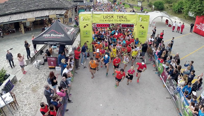
The start of the race takes place at the central square of Metsovo at an altitude of 1150m.
The route follows a wide cobbled road (Averoff street) to the park of Aghios Georgios. From the park, the route goes down a cobbled path, turns right at the fork and arrives in an asphalt road.
Soon we reach the point of separation of the two races (Ursa Trail and The Footsteps of the Bear). For the Footsteps of the Bear we go straight until we meet the main asphalt road which we follow westwards. For the next 3.2km we continued uphill until the seventh kilometer at an altitude of 1500m on top of the ski center Karakoli. This part is the most difficult of the race.
From the position Grizios, we take a narrow uphill asphalt street that passes through the old Tositsa institution's premises, where only a carpenter workshop still operates. We exit the site and go left at the asphalt road, cross the national road and reach the War Memorial, where the route enters a path.
This part of the route until "Politsoara" meadow has been decorated with works of the Athens School of Fine Arts, starting with the gateway where the path starts. The path crosses a small grove and soon reaches a sightseeing spot with seats made of tree trunks. The trail then climbs on a ridge (on our left we distinguish trenches of the Civil War) and reaches a resting point. From there we continue to the top of the lift of Metsovo ski resort near Karakoli summit.
From Karakioli we descend to the meadows of Politsoara, the 1st checkpoint at 7.5km from the start and at an altitude of 1415m.
From Politsoara we follow a wide path that soon passes by Daou spring (trough) and becomes a wider track. We then arrive at a crossroad and continue left on level terrain for about 1500 meters and then climb a path to the highest point of the ridge called "Kalligomeno Aloni" (1593 m), where we see a wind measuring mast on our left. We continue with slight descents and climbs on the ridge (we see trenches of WW2 on our left), pass a stone-built resting place with nice views and reach a col, where we turn right and begin to descend next to a stream. After 700 meters we enter a dirt road and soon reach a junction near the old wooden camp buildings of Vale Di Liosani, the second checkpoint at 13.5km from the start and at an altitude of 1400m.
We then take the right dirt road, pass a wooden bridge and climb gradually passing two other wooden bridges. After a relatively steep climb, the road descends and stops: we enter a path that intersects an asphalt road, slightly higher than the large fountain of Kria Vrisi. The path continues opposite, climbs up to a col, then descents tucked into woods and comes out again in the meadows. On street and path we reach the fountain Politsoara (two ponds) where we find the 3rd checkpoint at the 17th km and an altitude of 1400 m.
We continue on a dirt road for 100m and catch an uphill path that soon becomes a wider track and leads us near the summit Karakioli. From there we start a long descent to the base of the ski lift, following the ski piste (labeled "difficult route"). Arriving at the height of the cafe-teleferique, we cross the asphalt and enter a path. At 200 meters we enter a cement road that passes in front of the Pindos National Park Information Center. From there we descend first on cement road and next on wide cobbled path until we get to the central square of Metsovo. We go around the square before finishing.